Search Results
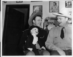
Rex Bell and Bill Froelich at Walking Box Ranch: photographic print
Dorothy Bell Scans UNLV-Public Lands Institute. Photograph of Rex Bell (George Francis Beldam) and Bill Froelich with dummy Charlie McCarthy at the bar of the game room in the ranch house at Walking Box Ranch.
Image
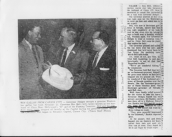
Newspaper clipping of Lt. Gov. Rex Bell giving a hat to North Carolina governor Luther Hodges in Raleigh, North Carolina: photographic print
Dorothy Bell Scans UNLV-Public Lands Institute
Text
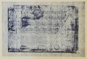
Original plat, townsite of Las Vegas, Lincoln Co., Nevada, January 13, 1905
Subtitle: 'Embracing the N. 1/2 of S.W. 1/4 Sec. 27 Township 20S. R.61E. Mt. Diablo Meridian.' 'Book 1, page 17A" handwritten in lower right corner. Signed by Henry Lee, County Recorder, Lincoln County Nevada. 'Filed at request of J.T. Williams, January 13th A.D. 1905.' Backwards handwriting on right side. Map has a Lincoln County seal on the bottom near the center. In the dedication J.T. McWilliams states that he has surveyed and platted the townsite of Las Vegas subject to the right of way of the San Pedro, Los Angeles and Salt Lake Railroad Company. He signed the dedication on Jan. 13, 1905, and it was signed by witnesses Scale [ca. 1:2,520? 1 inch to approx. 210 feet?]. Copy of a blueline print.
Image
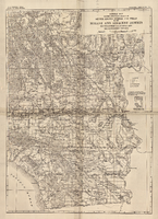
General map showing approximate location of better known springs and wells in the Mohave and adjacent deserts, southeastern California and southwestern Nevada, circa 1908-1909
224. Map is plate 1 from the U.S. Geological Survey Water-supply paper 224.
Image
Letter from Walter R. Bracken (Las Vegas) to F. H. Knickerbocker (Los Angeles), regarding cultivation of land from water of new well and springs to protect our water filings, November 15, 1924
Discussion of ways to put more land under cultivation to protect their water filings.
Text

The Overland, menu
Note: Cover has illustration showing height of "proposed Boulder Canyon Dam" in Black Canyon on the Colorado River, as compared to the Woolworth Building in New York City. Back cover has "Some Interesting Facts About Las Vegas, Nevada," including information about the proposed Boulder Dam, and which states that the Las Vegas Chamber of Commerce is "just a few doors north of this cafe." Restaurant: The Overland Location: Fremont St., Las Vegas, Nevada, United States
Text

Photograph album, Henry Wieking Collection, circa late 1920s-early 1930s
Image
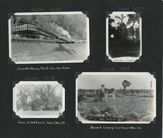
Photograph album, Henry Wieking Collection, circa late 1920s-early 1930s, page 1
Image
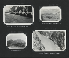
Photograph album, Henry Wieking Collection, circa late 1920s-early 1930s, page 2
Image
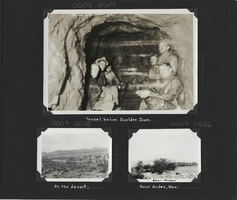
Photograph album, Henry Wieking Collection, circa late 1920s-early 1930s, page 3
Image