Search Results
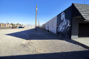
A painting of Mexican boxer Fernando Vargas adorns a wall in a commercial center near Civic Center Drive and Cheyenne Avenue in North Las Vegas, Nevada: digital photograph
From the UNLV University Libraries Photographs of the Development of the Las Vegas Valley, Nevada (PH-00394). Part of the collection documents the entire 19 mile length of the north/south Eastern Avenue / Civic Center Drive alignment. This photograph was captured in the section of Civic Center Drive between Alexander Road and Cheyenne Avenue.
Image
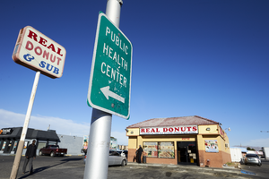
Signs for the Real Donut and Sub shop and the Public Health Center sit along Cheyenne Avenue near Civic Center Drive in North Las Vegas, Nevada: digital photograph
From the UNLV University Libraries Photographs of the Development of the Las Vegas Valley, Nevada (PH-00394). Part of the collection documents the entire 19 mile length of the north/south Eastern Avenue / Civic Center Drive alignment. This photograph was captured in the section of Civic Center Drive between Alexander Road and Cheyenne Avenue.
Image
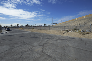
I-15 looms over a single family residential neighborhood on Hamilton Street, looking southwest in North Las Vegas, Nevada: digital photograph
From the UNLV University Libraries Photographs of the Development of the Las Vegas Valley, Nevada (PH-00394). Part of the collection documents the entire 19 mile length of the north/south Eastern Avenue / Civic Center Drive alignment. This photograph was captured in the section of Civic Center Drive between Cheyenne Avenue and Las Vegas Boulevard.
Image
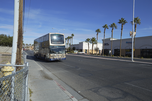
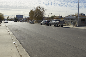
An RTC bus travels on Civic Center Drive near Cheyenne Avenue, looking north in North Las Vegas, Nevada: digital photograph
From the UNLV University Libraries Photographs of the Development of the Las Vegas Valley, Nevada (PH-00394). Part of the collection documents the entire 19 mile length of the north/south Eastern Avenue / Civic Center Drive alignment. This photograph was captured in the section of Civic Center Drive between Cheyenne Avenue and Las Vegas Boulevard.
Image
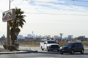
A Smith's grocery store sign and Las Vegas skyline behind the roundabout on East Carey Avenue and Hamilton Street in North Las Vegas, Nevada: digital photograph
From the UNLV University Libraries Photographs of the Development of the Las Vegas Valley, Nevada (PH-00394). Part of the collection documents the entire 19 mile length of the north/south Eastern Avenue / Civic Center Drive alignment. This photograph was captured in the section of Civic Center Drive between Cheyenne Avenue and Las Vegas Boulevard.
Image
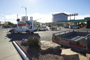
North Las Vegas City Hall behind a U-Haul business on the corner of Las Vegas Boulevard and Civic Center Drive in North Las Vegas, Nevada: digital photograph
From the UNLV University Libraries Photographs of the Development of the Las Vegas Valley, Nevada (PH-00394). Part of the collection documents the entire 19 mile length of the north/south Eastern Avenue / Civic Center Drive alignment. This photograph was captured in the section of Civic Center Drive between Cheyenne Avenue and Las Vegas Boulevard.
Image
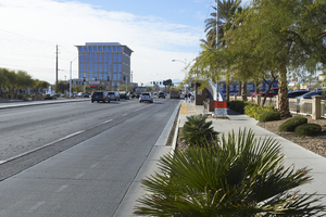
North Las Vegas City Hall near the intersection of Las Vegas Boulevard and Civic Center Drive in North Las Vegas, Nevada: digital photograph
From the UNLV University Libraries Photographs of the Development of the Las Vegas Valley, Nevada (PH-00394). Part of the collection documents the entire 19 mile length of the north/south Eastern Avenue / Civic Center Drive alignment. This photograph was captured in the section of Civic Center Drive between Cheyenne Avenue and Las Vegas Boulevard.
Image
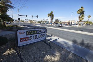
A sign for Rapid Cash loans business along East Carey Avenue near Civic Center Drive in North Las Vegas, Nevada: digital photograph
From the UNLV University Libraries Photographs of the Development of the Las Vegas Valley, Nevada (PH-00394). Part of the collection documents the entire 19 mile length of the north/south Eastern Avenue / Civic Center Drive alignment. This photograph was captured in the section of Civic Center Drive between Cheyenne Avenue and Las Vegas Boulevard.
Image
North Las Vegas City Hall is seen behind a residential neighborhood on Civic Center Drive in North Las Vegas, Nevada: digital photograph
From the UNLV University Libraries Photographs of the Development of the Las Vegas Valley, Nevada (PH-00394). Part of the collection documents the entire 19 mile length of the north/south Eastern Avenue / Civic Center Drive alignment. This photograph was captured in the section of Civic Center Drive between Cheyenne Avenue and Las Vegas Boulevard.
Image
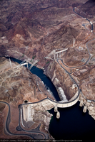
Photograph showing an aerial view of Hoover Dam, the original road between Arizona and Nevada, and the Mike O'Callaghan-Pat Tillman Memorial Bridge under construction, Nevada-Arizona border, May 22, 2009
Image