Search Results
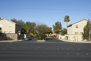
Single family homes flank the entrance to the Villa Sedona development across from the Palm Eastern Mortuary and Cemetery on Eastern Avenue, looking west-southwest in Las Vegas, Nevada: digital photograph
From the UNLV University Libraries Photographs of the Development of the Las Vegas Valley, Nevada (PH-00394). Part of the collection documents the entire 19 mile length of the north/south Eastern Avenue / Civic Center Drive alignment. This photograph was captured in the section of Eastern Avenue between Warm Springs Road and Windmill Parkway.
Image
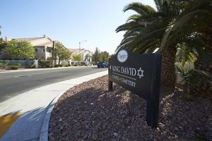
A sign touting the King David Chapel and Cemetery sits on Eastern Avenue with multi-family housing, looking northeast in Las Vegas, Nevada: digital photograph
From the UNLV University Libraries Photographs of the Development of the Las Vegas Valley, Nevada (PH-00394). Part of the collection documents the entire 19 mile length of the north/south Eastern Avenue / Civic Center Drive alignment. This photograph was captured in the section of Eastern Avenue between Warm Springs Road and Windmill Parkway.
Image
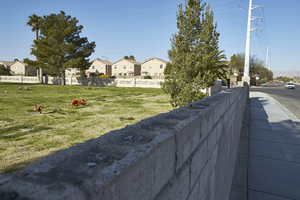
Single family homes sit across Eastern Avenue from the Palm Eastern Mortuary and Cemetery on Eastern Avenue, looking southwest in Las Vegas, Nevada: digital photograph
From the UNLV University Libraries Photographs of the Development of the Las Vegas Valley, Nevada (PH-00394). Part of the collection documents the entire 19 mile length of the north/south Eastern Avenue / Civic Center Drive alignment. This photograph was captured in the section of Eastern Avenue between Warm Springs Road and Windmill Parkway.
Image
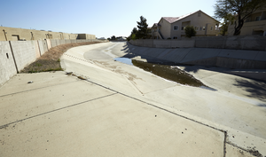
A flood channel separates commercial and residential housing along Eastern Avenue, looking north-northwest in Las Vegas, Nevada: digital photograph
From the UNLV University Libraries Photographs of the Development of the Las Vegas Valley, Nevada (PH-00394). Part of the collection documents the entire 19 mile length of the north/south Eastern Avenue / Civic Center Drive alignment. This photograph was captured in the section of Eastern Avenue between Warm Springs Road and Windmill Parkway.
Image
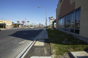
Commercial development along Eastern Avenue at near Warm Springs Road, looking west-northwest in Las Vegas, Nevada: digital photograph
From the UNLV University Libraries Photographs of the Development of the Las Vegas Valley, Nevada (PH-00394). Part of the collection documents the entire 19 mile length of the north/south Eastern Avenue / Civic Center Drive alignment. This photograph was captured in the section of Eastern Avenue between Warm Springs Road and Windmill Parkway.
Image
Traffic flows on Warm Springs Road near Eastern Avenue where commercial and residential development meet, looking east in Las Vegas, Nevada: digital photograph
From the UNLV University Libraries Photographs of the Development of the Las Vegas Valley, Nevada (PH-00394). Part of the collection documents the entire 19 mile length of the north/south Eastern Avenue / Civic Center Drive alignment. This photograph was captured in the section of Eastern Avenue between Warm Springs Road and Windmill Parkway.
Image
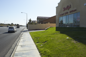
Landscaping for a commercial development on Warm Springs Road near Eastern Avenue, looking west-southwest in Las Vegas, Nevada: digital photograph
From the UNLV University Libraries Photographs of the Development of the Las Vegas Valley, Nevada (PH-00394). Part of the collection documents the entire 19 mile length of the north/south Eastern Avenue / Civic Center Drive alignment. This photograph was captured in the section of Eastern Avenue between Warm Springs Road and Windmill Parkway.
Image
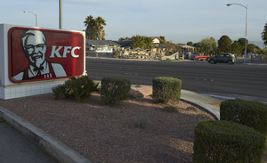
A KFC fast food sign with single family homes across Windmill Parkway near Eastern Avenue, looking north-west in Las Vegas, Nevada: digital photograph
From the UNLV University Libraries Photographs of the Development of the Las Vegas Valley, Nevada (PH-00394). Part of the collection documents the entire 19 mile length of the north/south Eastern Avenue / Civic Center Drive alignment. This photograph was captured in the section of Eastern Avenue between Windmill Parkway and Pebble Road.
Image
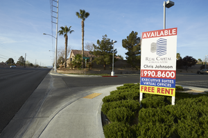
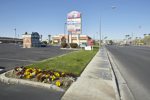
Landscaping and signs for a commercial development next to single family homes on Eastern Avenue south of Windmill Parkway, looking south-southwest in Las Vegas, Nevada: digital photograph
From the UNLV University Libraries Photographs of the Development of the Las Vegas Valley, Nevada (PH-00394). Part of the collection documents the entire 19 mile length of the north/south Eastern Avenue / Civic Center Drive alignment. This photograph was captured in the section of Eastern Avenue between Windmill Parkway and Pebble Road.
Image
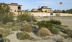
Land for sale along Wigwam Avenue with custom homes and a cell phone tower near Eastern Avenue, looking west-northwest in Las Vegas, Nevada: digital photograph
From the UNLV University Libraries Photographs of the Development of the Las Vegas Valley, Nevada (PH-00394). Part of the collection documents the entire 19 mile length of the north/south Eastern Avenue / Civic Center Drive alignment. This photograph was captured in the section of Eastern Avenue between Windmill Parkway and Pebble Road.
Image