Search Results
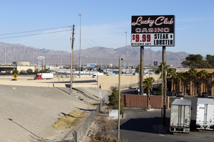
Signage for the Lucky Club Casino, looking north towards I-15 in North Las Vegas, Nevada: digital photograph
From the UNLV University Libraries Photographs of the Development of the Las Vegas Valley, Nevada (PH-00394). Part of the collection documents the entire 19 mile length of the north/south Eastern Avenue / Civic Center Drive alignment. This photograph was captured in the section of Civic Center Drive between Alexander Road and Cheyenne Avenue.
Image
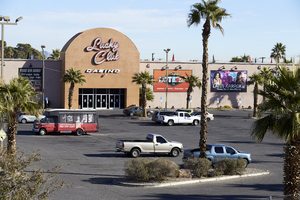
Exterior view of the Lucky Club Casino in daylight, looking northeast in North Las Vegas, Nevada: digital photograph
From the UNLV University Libraries Photographs of the Development of the Las Vegas Valley, Nevada (PH-00394). Part of the collection documents the entire 19 mile length of the north/south Eastern Avenue / Civic Center Drive alignment. This photograph was captured in the section of Civic Center Drive between Alexander Road and Cheyenne Avenue.
Image
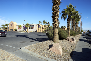
Exterior view of the Lucky Club Casino in daylight, looking northwest in North Las Vegas, Nevada: digital photograph
From the UNLV University Libraries Photographs of the Development of the Las Vegas Valley, Nevada (PH-00394). Part of the collection documents the entire 19 mile length of the north/south Eastern Avenue / Civic Center Drive alignment. This photograph was captured in the section of Civic Center Drive between Alexander Road and Cheyenne Avenue.
Image
Penn National Gaming to Temporarily Suspend Operations at Its Casinos in Nevada: archived website, 2020
Collection Name: UNLV Libraries Collection of Digital Communication about COVID-19 in Las Vegas
Box/Folder: N/A
Archival Component
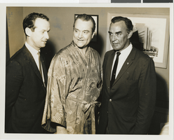
Photograph of Tom Tierney, Martin Mac Nealy, and Al at the Sands Hotel and Casino, Las Vegas, circa mid 1950s - early 1960s
Image
Tropicana Hotel Casino and Country Club: Las Vegas, Nevada, 1958 November 15; 1962 September 27
Collection Name: Homer Rissman Architectural Records
Box/Folder: N/A
Archival Component
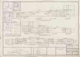
Architectural drawing of addition, Sahara Hotel and Casino (Las Vegas), interior elevations, March 18, 1960
Interior elevations, cross sections, and interior design details for the renovation of the Sahara from 1960. Includes revisions. Printed on onion skin.
Site Name: Sahara Hotel and Casino
Address: 2535 Las Vegas Boulevard South
Image
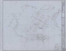
Architectural drawing of the International Hotel (Las Vegas), casino gaming plan, August 5, 1968
Architectural plans for the International Hotel, Las Vegas, Nevada from 1968. Printed on mylar; delineator identified with the initials DEC. Berton Charles Severson, architect; Brian Walter Webb, architect.
Site Name: International Hotel
Address: 3000 Paradise Road
Image
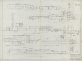
Architectural drawing of the Hacienda (Las Vegas), casino elevations and sections, March 11, 1955
Finalized construction plans for the construction of Hacienda, originally called the Lady Luck, as written on the drawing. Drawn by: T.G. Efstonbuilt, Inc. of Chicago, architects; Harold L. Epstein, structural engineer; A. E. Capon, electrical engineer.
Site Name: Hacienda
Address: 3590 Las Vegas Boulevard South
Image
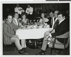
Photograph of guests at a dining table in the Sands Hotel and Casino, Las Vegas, November 1962
Image